
Plate Boundaries:
Constructive, Destructive, and Conservative Margins
How the movement of tectonic plates shapes Earth’s surface
The Earth’s rigid outer shell, the lithosphere, is broken into massive tectonic plates that float on the slowly churning mantle beneath. Most of the planet’s dramatic geological action – earthquakes, volcanoes, mountain building – happens where these plates meet. These meeting lines are called plate boundaries or margins.
Geologists group plate boundaries into three main types, based on how the plates move relative to one another: constructive (divergent), destructive (convergent), and conservative (transform). Each type creates distinctive landforms and hazards.

1. Constructive (Divergent) Plate Boundaries
At a constructive or divergent boundary, two plates move away from each other. As they separate, hot magma from the mantle rises to fill the gap, cools and solidifies, creating new crust. This is why such boundaries are called “constructive”.
Sea‑floor spreading and mid‑ocean ridges
When divergence happens beneath an ocean, the process is called sea‑floor spreading. The rising magma forms a long underwater volcanic mountain chain known as a mid‑ocean ridge. The Mid‑Atlantic Ridge is the best‑known example. Here, the Atlantic Ocean widens by about 2–5 cm per year. The newest rocks sit right at the ridge crest, and their age increases steadily outward.
Eruptions along mid‑ocean ridges produce a distinctive rounded lava shape called pillow lava, which cools quickly on the ocean floor. Over time, some underwater volcanoes grow tall enough to break the surface. The island of Iceland was formed this way, and new islands like Surtsey (1963‑1967) and Heimaey (1973) have appeared in historical time.
Other major mid‑ocean ridges include the East Pacific Rise, the Pacific‑Antarctic Ridge, and the Carlsberg Ridge. Almost three‑quarters of all lava reaching Earth’s surface each year erupts along such ridges.
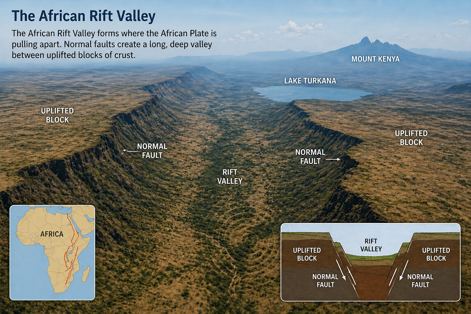
Rift valleys – divergence on land
When plates pull apart within a continent, they create a rift valley. The Great African Rift Valley stretches for about 4000 km from the Red Sea to Mozambique. It is between 10 and 50 km wide, with steep sides up to 600 metres high. This rifting may eventually split East Africa from the rest of the continent and form a new ocean.
2. Destructive (Convergent) Plate Boundaries
At a destructive or convergent boundary, two plates move towards each other. Because oceanic crust (sima) is denser than continental crust (sial), when the two meet, the heavier oceanic plate is forced downward into the mantle in a process called subduction. This recycles old crust, hence the name “destructive”. Convergent boundaries are responsible for the most violent earthquakes and volcanic eruptions.
Subduction zones and ocean trenches
Where the oceanic plate bends and sinks, a deep‑sea trench or subduction zone forms. The Peru–Chile Trench reaches 8050 metres deep, while the world’s deepest is the Mariana Trench in the western Pacific at an astonishing 11 022 metres.
As the descending plate scrapes deeper, immense pressure and friction cause it to crack, generating large earthquakes. The subducted crust melts and forms new magma, which is lighter than the surrounding mantle. This magma rises along weaknesses in the crust, feeding explosive volcanoes.
Island arcs
When the rising magma breaks through the sea floor, it builds a chain of volcanic islands known as an island arc. The Windward and Leeward Islands in the Caribbean are a classic example, formed where the South American plate subducts beneath the Caribbean plate. Other island arcs dot the Pacific “Ring of Fire”.
Collision zones – when continents collide
If two continental plates converge, neither can easily sink because continental crust is too buoyant. Instead, they crash together in a collision zone. The crust buckles, fractures, and is pushed upward to form enormous fold mountains. The Himalayas, the world’s highest mountain range, began forming when the Indian plate rammed into the Eurasian plate. India continues to push northward at about 5 cm per year, and marine fossils high in the Himalayas prove that the rocks were once a sea floor (the ancient Tethys Sea). Collision zones produce large earthquakes but no volcanic activity.

3. Conservative (Transform) Plate Margins
At a conservative or transform margin, two plates slide horizontally past each other. Crust is neither created nor destroyed – it is conserved. There is no volcanic activity, but enormous stress can build up when the plates “stick” along the fault. When that stress is suddenly released, a devastating earthquake can occur.
The most famous example is the San Andreas Fault in California. In the 1906 San Francisco earthquake, the ground shifted by up to 6 metres and the quake measured 8.3 on the Richter scale. Over 450 people died and nearly 30 000 buildings were destroyed. The fault remains a persistent seismic threat.
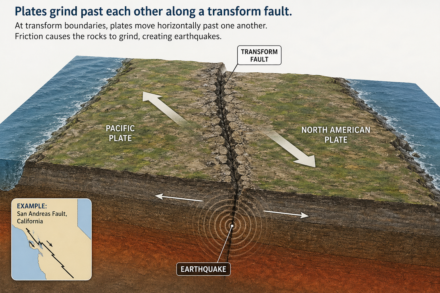
Plate Boundaries and Tectonic Activity – Summary
| Type of plate boundary | Earthquake / volcanic activity |
|---|---|
| Divergent (constructive) | Gentle volcanic and earthquake activity |
| Convergent (destructive) – subduction | Violent volcanic and earthquake activity |
| Convergent – collision zone | Earthquake activity (no volcanic activity) |
| Transform (conservative) | Can be violent earthquake activity (no volcanic activity) |
The Caribbean Plate and Adjacent Boundaries
The islands of the Caribbean owe their existence to active plate boundaries. The Caribbean plate is moving eastward relative to South America and is surrounded by all three boundary types.
- Divergent: A short constructive boundary exists west of Jamaica – the Cayman Island Ridge. Gentle earthquake and volcanic activity can occur here.
- Convergent: The eastern Caribbean is an active island arc where the South American plate subducts beneath the Caribbean plate. The chain stretches from Saba to Grenada and includes volcanoes like Soufrière on Montserrat. The deep Puerto Rico Trench (8400 m) marks part of this zone.
- Transform: The boundary running through Jamaica, Hispaniola and Puerto Rico is now a transform margin, where earthquakes remain a major hazard.
Fold mountains also appear along the southern edge of the Caribbean, in northern Venezuela and Trinidad, where plates have collided. Only a few Caribbean territories – the Bahamas, Suriname and Guyana – lie on geologically stable continental areas, largely free from tectonic disasters.